les trois becs par col de la chaudière

losjo
User
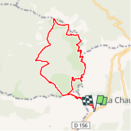

Length
10.9 km

Max alt
1561 m

Uphill gradient
846 m
Km-Effort
22 km

Min alt
1032 m

Downhill gradient
846 m
Boucle
Yes
Creation date :
2018-03-15 00:00:00.0
Updated on :
2018-03-15 00:00:00.0
4h28
Difficulty : Difficult

FREE GPS app for hiking
 SityTrail
IGN / Geographical institutes
SityTrail Plus
The world is yours!
About
Trail Walking of 10.9 km to be discovered at Auvergne-Rhône-Alpes, Drôme, La Chaudière. This trail is proposed by losjo.
Positioning
Country:
France
Region :
Auvergne-Rhône-Alpes
Department/Province :
Drôme
Municipality :
La Chaudière
Location:
Unknown
Start:(Dec)
Start:(UTM)
674881 ; 4944140 (31T) N.
Comments